

The fetid musk of South Side slaughterhouses, the eclectic sprawl of Dublin, the muck of the Everglades: these sensual ambiences enwrap readers of The Jungle, Ulysses, and Their Eyes Were Watching God. Between those pages, space and atmosphere seems to “thicken, take on flesh,” as Mikhail Bakhtin wrote. These novels are exemplars, of course, but in general we don’t hesitate to label great fiction “immersive”; prose, at its best, can produce a powerful corporeal experience as well as a cognitive one. Why are we are reluctant to believe that historiography could do the same?
Historical research, we presume, benefits from coolness, neutrality, and critical distance. But the appeal to a sense of place, not just describing but making palpable distant or bygone scenery in all its spatial and social complexity, is not the responsibility of novelists alone. Reenactors, cultural preservationists, and open-air museum curators have demonstrated for more than a century that interactive history has not only entertainment value but also real heuristic potential, and it’s refreshing to work among academic historians eager to enrich historical narrative on—and beyond—the printed page.
For digital humanists working on histories of space and place, representing practice appears to be the current frontier of the technologically possible. Practice is French Marxist geographer and cultural critic’s Henri Lefebvre’s term, one of three composing the iconic “spatial triad” he unveils in The Production of Space. By practice, he refers not to the perceivable patterns and physical structures that demarcate our lived environments—Chicago’s elegant gridiron, for example, or the boggling angles and inclines of a suburban parking garage—but rather to the everyday activities that inform and shape our experience of space. Out of the mute fabric of open terrain, we sew complexly textured quilts of public and private meaning sensible only to us; memory and affect attach themselves to familiar sites and await their resuscitation each time we draw near.
Tangible patterns and structures are, of course, rather easily reproducible in virtual space. Many digital humanities projects succeed in generating multilayer, customizable, information-dense, yet highly legible maps that show, for example, patterns of German-Jewish emigration or mafia territory during Prohibition. These interactive diagrams are inarguably useful, and can provide necessary context and a sense of scale to otherwise dry historical narratives. But experience and memory remain notoriously hard to incorporate into digital interfaces. The challenge today is to push digital mapping technologies (also known as Geographic Information Systems, or GIS) beyond the ontic limitations of the map, before the map “pushes us back,” as Lefebvre predicted “towards a purely descriptive understanding” of history.
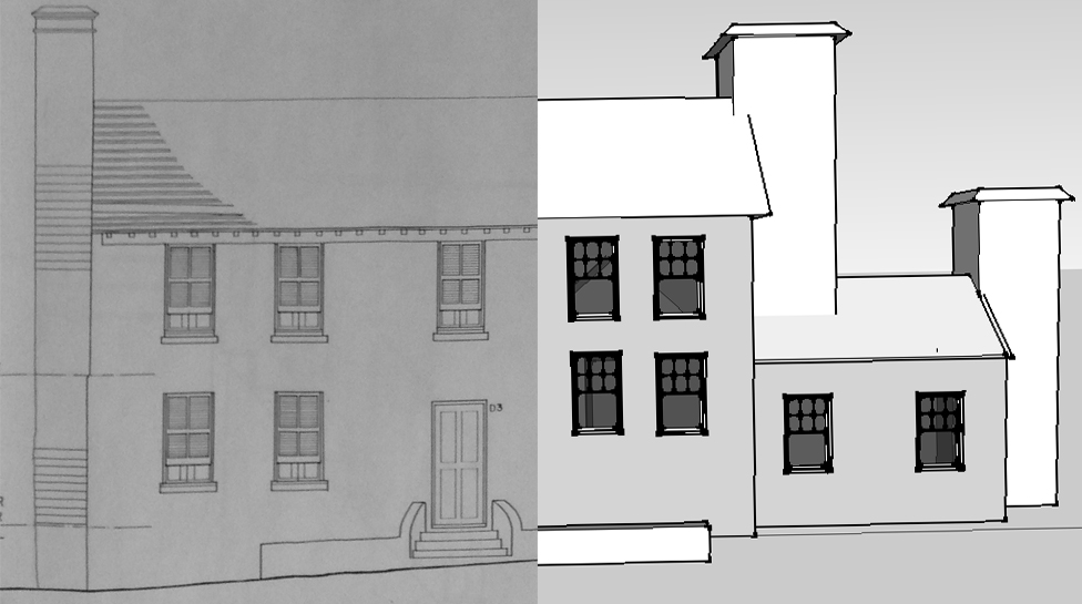
As an Andrew W. Mellon Fellow in Digital Humanities, I have the good fortune to work with Dr. Michael Jarvis, a historian at the University of Rochester specializing in the Atlantic maritime world, in particular the cultural and geopolitical role played by Bermuda during the eighteenth and nineteenth century. Virtual St. George’s, his ambitious, year-old digital history project, makes use of multiple mediums and platforms—architectural rendering, digital cartography, drone photography, 3-D scanning—in an effort to electronically, interactively, immersively reconstruct space-as-experienced and life-as-lived across multiple eras in St. George’s, the colonial capital of the mid-Atlantic island. Jarvis summarizes the project’s objective best:
The project’s various historicized 3D townscapes will help visitors visualize how St. George’s evolved through adaptations to environmental change, world events, fluctuating global markets, local demographic shifts and architectural influences. Engagement can vary from particular exploration of individual building interiors using probate inventories (like a virtual house museum in the style of Colonial Williamsburg, Sturbridge Village, Greenfield Village) to an open-ended urban exploration of the town’s docks, warehouses, and streets filled with animated St. Georgian avatars. We plan ultimately to incorporate game-play missions (such as delivering letters to a royal governor, haggling with a ship captain or merchant, aiding an enslaved sailor to escape) to engage users of different ages in order to give direction and purpose to their spatial explorations, teach social science skills, and represent historical realities.
I see Virtual St. George’s as more than an opportunity to experiment with historical storytelling methods, and to spark conversation about the potentials—and practical limits—of the virtual sensorium. It will also model for the interoperability of multiple DH platforms that are now primarily used in isolation, and demonstrate the value of the virtual to preservationist efforts. As the Virtual St. George’s graduate assistant, I’ll be blogging here in the future about the project’s progress, as well as about the intersections and interstices of digital history, video games, virtual reality technology (e.g., Oculus Rift), drone photography, critical theory, and phenomenology.
—
Eitan Freedenberg is an Andrew W. Mellon Fellow in Digital Humanities and a PhD student in the Graduate Program in Visual and Cultural Studies at the University of Rochester.