
By Maxwell Sheldon
Technical Assistant

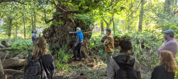
Nested behind President Mangelsdorf’s backyard sits a landscape of winding paths among meadow-turning patches, and encapsulating tree canopies once home to a tree nursery from the days of horticulturists Ellwanger and Berry. Karl Rosengren, Professor in the Department of Brain and Cognitive Sciences and the Department of Psychology, welcomed students from Professor Fry’s Natural History course into this once locked space toward the substantial remains of a former NY State Champion Willow tree (now a humongous knobby old stump). Professor Rosengren expressed his desire to eventually open the space up for all students to wander and roam, and to install trail cams to record the curious wildlife that inhabit it.
Fry’s students will join GIS Specialist, Blair Tinker, of the Digital Scholarship Lab, in collecting tree attribute data from this unmapped site to add to the University arboretum’s geodatabase, a project kicked off by student Lillian Henderson in 2018 that has since blossomed into an interdepartmental team geotagging effort.
Mapping the University’s myriad trees to an online geospatial database (or “the cloud”) brings us closer in touch with their health and growth patterns, presenting further opportunities for immersive information dissemination and ecologically-minded maintenance decisions. Building upon previous monitoring techniques of nail-in tagging and logging tree attributes in excel, the deployment of ArcGIS Online (Geographic Information Systems) links remote information storage to each tree’s GPS position, and does not require invasive physical tagging.
Engaging with each tree’s unique characteristics and history will add another layer of enjoyment to the visitor’s experience, and will build awareness of seasonality. Currently, McIntyre offers a tree tour that adapts stops to include flowering trees based on the timing of the tour. Once the trees are in the geodatabase, visiting students can choose to access information including genus, species, DBH (diameter at breast height), height, and more as they approach them in space.
Moving forward, the geodatabase opens up a range of opportunities from a management perspective. Maintenance workers can record notable changes to a dynamic online map, while the grounds manager gains a filterable eagle-eye view of the property to support decision-making and delegation. The manager can select for oak trees in the event of an oak blight and assign protections that workers will see in the field. They can also strategically revoke insect or fungal protection measures to certain trees when ecologically favorable.